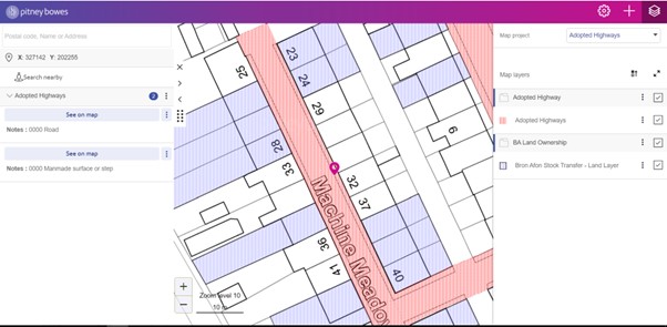
If you are checking ownership of land, you will need to use the adopted highway map.
This will show you who owns the land. It will either be Bron Afon, Torfaen Council or private owners.
The key on the right hand side of the map (under the set of squares) will help you identify the owener.
Search for the address or area in the search box on the left hand side of the screen.
Purple land, is Bron Afon owned.
Red land, is Torfaen Council owned.
White land, is privately owned. We hold no records of owners so the customer will need to contact Torfaen Council for further help or the land registry.
It is important to check the Adopted Highway map as in some cases the land will show as white on default, but the adopted highway map will confirm it is the responsibility of TCBC. (See below example) Please ensure you always check the adopted highway map.